Natural History Audio Tour
Jump to:
Audio Tour Playlist
Topic Outline
Map
Transcripts
Pop your headphones on and join Matt, our Conservation Program Manager, for a guided walk from our Farm Stand, through our front field, to the riparian forest along the edge of the Snoqualmie River. Uncover the hidden geological and cultural history of the landscape.
Audio Tour Playlist
Topic Outline
Stop 1
Introduction
[0:33-1:06] Directional Orientation
[1:07-1:50] Instructions
Geological Context
[1:51-2:54] Eocene Epoch Environment
[2:55-3:38] Plate Tectonics
[3:39-3:55] Exotic Terranes Formation
[3:55-5:15] Mountain & Volcano Development
Stop 2
Ecological Context
[0:00-0:34] Wetland Wildlife
[0:35-1:08] Oxbow Lake Formation
[1:09-2:02] Significance of the Snoqualmie
[2:03-4:47] Glacially-carved Topography
Stop 3
Human Influence
[0:00-0:39] Orientation & Land Acknowledgment
[0:40-1:11] Indigenous Land Stewardship
[1:12-1:39] European Settlement
[1:40-2:54] Logging & Agriculture
[2:55-4:12] Transportation Infrastructure
[4:13-7:50] Inflow of Non-native Species
Stop 4
Restoration & Recovery
[0:00-0:19] Orientation
[0:20-1:13] River Alterations & Habitat Loss
[1:14-2:52] Community Restoration Efforts
[2:53-4:47] Conclusion & Call to Action
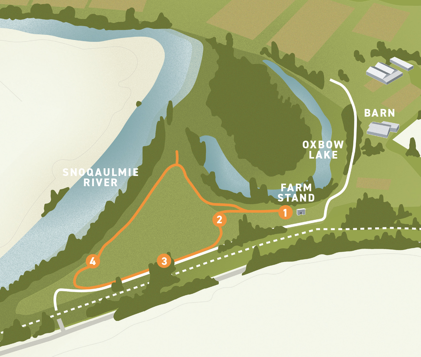
Map
Follow the mowed path and look for tour stop signs as you embark on the Front Field Loop, a 0.6-mile trail showcasing our lake, meadow, river, and alder grove restoration site.
Transcripts
Welcome to Oxbow’s audio-guided History and Nature walk! I’m Matt Distler, the Conservation Program manager at Oxbow, and I’ll be your guide, hopefully providing you with a sense of the deeper story of human and natural history that lies behind the beautiful scenery of the Snoqualmie Valley’s fields and forests. We’ll be starting here at the Farm Stand, where we share our organic veggies and native plants with our community, a great place to meet up for a weekend work party, an educational program, or a stroll around Oxbow’s trail system.
To start out, let’s make sure you have some sense of direction here. As you stand facing the starting sign for this walk, you are facing west. Down the shrubby slope you can see Oxbow’s eponymous “oxbow lake” – we’ll talk more about it soon. If you turn to your right, you see the farm stand area and the road that leads northwest around the oxbow lake to the central barn, kids farm, native plant nursery, and production fields. If you turn to your left (south) you can see Oxbow’s grassy front field and the distant stand of alders standing along the river, beyond the fields. This guided walk will take you part of the way around Oxbow’s Front Field Loop, a 0.6 mile loop that encircles the field along which you drove in (if you came by car), and you’ll see our lake, fields, and some ecological restoration sites as you go.
Are you ready?
Ok.
Turn to your left, toward the fields and keeping the shrubs and Oxbow lake to your right, you can walk along an old farm road that starts out our Front Field Loop. The trail markers will occasionally help you keep on the trail, but you can also pick up a trail map at the Farm stand, or use your mobile device to go on our website to see our trails. Our next audio tour stop.
Sometimes we all want to return to an earlier, simpler, time, don’t we? Ok, as we’re walking, imagine for a moment that you are taking this tour 40 million years ago – during the Eocene epoch. The climate is warm and humid, the continents are just settling into the positions we’re familiar with today, and the land-going ancestors of today’s whales are beginning to return to the sea. So, how should we dress if we were taking this walk then (56 to 37 million years ago)? The answer is: scuba gear! The area where you’re standing now was the edge of a shallow sea. You might have been able to see the shoreline of the continent as we can see the foothills of the Cascades from where you are now. The gently-sloping coastal plain you could have seen across the waves was likely dotted by vast peat swamps, whose peat deposits, once buried and metamorphosed, would slowly form the western Washington coal deposits that made coal boomtowns with evocative names like Newcastle and Black Diamond famous coal centers in the early 20th century.
However, as we stand here in the Eocene, things are also changing that will create new land on the edge of our growing continent. Through plate tectonics, the giant bedrock slab which lies under the eastern pacific – called the Juan de Fuca crustal plate — was at that time (and still is) sliding (subducting) under the crustal plate of the north American continent, something like the way a thin cutting board might be slid under a table runner on a table if you pushed them together. As the Juan de Fuca plate dove beneath the North American Plate, island chains sitting atop the Juan de Fuca plate (imagine food scraps on our cutting board) were scraped off, one by one, and joined to the growing west coast of the North American continent (Alt and Hyndman 1995, Dragovitch et al 2011). In fact, geological evidence indicates that these “scraps” or “exotic terranes” as they’re known to geologists, formed all the land west of the modern Washington-Idaho border, docking in about 50 episodes from 100 million to 5 million years ago. If we go back to our imaginary cutting board and table runner, you can imagine that sliding the cutting board under could rumple up the edge of the runner, and in fact some of the more violent collisions/subductions periods caused the North American plate to rumple up into ranges of mountains, known today as the Cascades and Olympic mountains, each of which reached their maximum height about 2-5 million years ago . With these events came episodes of vulcanism as well. As parts of the subducting plate became molten and rose through the crust, they birthed a series of volcanos along the ancient coast. If it’s a nice day- you can look out to the south (across the fields and up the valley) and see rugged faces of Mt. Si and its neighbors. These mountains are the remains of these ancient volcanoes that started in the shallow off-shore areas and then were subsequently “rumpled up” by those tectonic forces we just discussed.
The modern Cascades volcanoes– Mt. Rainier, Mt. St. Helens, Mt. Adams – are the product of a later episode of vulcanism. OK. Look for the “Stop 2” sign at the split in the trail (where we’ll head left toward the entrance road).
Hi again! Our trail is going to head away from the lake in minute (though it will loop back here), but before we head out into the field, let’s take another look at the lake through the trees and think a little about it. Ecologically, the lake and surrounding wetlands are the nexus of the property, with the aquatic ecosystem and myriad wetland plants supporting fish, waterfowl, frogs and salamanders, muskrat, mink, otter, and beaver and the riparian forests supporting a rich range of forest understory plants, mammals such as coyotes, and dozens of species of native songbirds.
An oxbow is a particular kind of lake that forms from when a river erodes a shortcut between a more upstream bend and a more downstream bend. When this happens, the river abandons the intervening river bend and leaves a low, wet lake in the old, abandoned stretch of river bed. Our oxbow lake is an especially young one. When surveyors came through to plat the land in the 1870s, they mapped the oxbow as an active bend of the Snoqualmie River, and one can see from 1936 aerial photos that it was just beginning to abandon this channel in the 30’s.
The Snoqualmie River is in so many ways the center of this landscape. The river waters the land and once supported great swamps and forests, seasonal flooding built the amazing fertility of the lowlands that now support farms and ranches, the river facilitated travel and early settlement, and is home to a wealth of aquatic life, supporting the food chain of the surrounding landscape and the salmon that are so central to the life ways of native peoples and to the identity of many Northwesterners. Like many of our Puget sound area rivers, its path is partly defined by the deep geological history we discussed at our first stop: it flows north-south in the folds created by the rumpling up of the cascade foothills millions of years ago. The shape of the valley, the sediments and soils it runs through, and the quirky hills and dales around it were all shaped by the interplay of the river and another, more recent geological force, however: glaciers.
From about 2 million years ago until 10,000 years ago, the earth experienced a long series of cold glacial periods (known as ice ages), each lasting 40-70,000 years. Ice sheets formed and spread south across the northern part of our continent. During the last episode of glaciation (from about 14,500 years ago and 13,600 years ago) the land you’re standing on was ploughed over by a giant sheet of ice hundreds of feet thick.
If you’re still facing the oxbow lake, look left, up the Snoqualmie River valley toward Mt. Si and the lower cascades. Imagine tongues of ice, hundreds of feet over your head, pushing their way up the Snoqualmie River valley and adjacent Sammamish and Puget basins, bulldozing up mountains of crumbling rocks and debris and dammed up entire river valleys for hundreds of years. The tongue of ice that came up the Snoqualmie Valley ground to a halt just above the modern town of North Bend. With the valleys north of that dammed by ice, a series of massive pro-glacial (glacier-edge) lakes, fed by the continued flow of mountain streams and tributaries, filled the upper valleys. As the waters rose up the valley walls, they overflowed and began to carve connecting channels to adjacent, parallel valleys, so that water from the Snoqualmie valley cascaded over to the Sammamish basin and from there across to the Cedar/Lake Washington basin, draining west from valley to valley along the edge of the glacial terminus and eventually out to the ocean via the Chehalis River valley. The channels carved by these glacial waters remain in our landscape, echoes of this cataclysmic but temporary reorganization of the regions rivers – kind of a geological secret code: If you drive on the Preston-Fall City Road along the Raging River or along Hwy 202 and Patterson Creek or up I-90 between Issaquah and Preston, you are following the channels carved by these waters as they sought new routes to the sea around the blocking ice.
As the glacier began to recede again, glacial meltwaters and glacier-marginal rivers deposited deep, sorted strata of sand and gravel, forming hills and hillslope formations called kames, like the gravelly hillside you can see across the highway (further to your left) now. These valley wall deposits now provide the materials that support gravel mining operations such as Cadman industries’ High Rock mine near Monroe, which sits upon the High Rock kame complex (Dragovitch et al. 2011). Ok, lets move on, keeping to the left branch that heads back toward the entrance road you came in on, and stop at Stop 3, out in the field near the gravel entrance road.
You’re standing in Oxbow’s so-called “front field” now, where we often grown pumpkin and other veggies, with the sounds of traffic in the background from Highway 203 reminding us of people going about their business up and down the valley. It’s a good place to consider that geological forces aren’t the only ones that have shaped our landscape over the years. Humans have been a part of the story of this landscape as far back as we know. Oxbow acknowledges that we are on the Indigenous Land of Coast Salish peoples who have reserved treaty rights to this land, specifically the Snoqualmie Indian Tribe (sdukʷalbixʷ). We thank these caretakers of this land who have lived, and continue to live, here since time immemorial.
Coast Salish peoples through the ages knew intimately the many plants and animals in the region and used them to produce all of their food, shelter, and their material culture in a system of seasonal gathering and preserving across the Puget Sound landscape. Using deep knowledge and technical expertise developed over thousands of years, they shaped and maintained the plant communities they depended on– especially the prairie areas that were burned regularly in order to provide a sustainable source of important staple foods like camas and bracken.
When European settlers began to enter the area, they made different and more drastic changes to the landscape, changing the relationship that Coast Salish people were able to have with the land, as they were moved to reservations after signing treaties. In the wake of the Point Elliott treaty and following battles between local tribes and white settlers, retired soldiers accelerated their settlement of the valley and the many changes wrought by Euro-American land uses.
Early farmers such as Jeremiah Borst transformed a vast prairie in North Bend that had been maintained and cultivated by the Snoqualmie People to European-style agriculture, and other settlers followed, farming and logging the valleys lowlands and forests. In the half century between the 1870s and 1930s, about 75% of the valley’s forest was logged and most of the land (previously covered by thickets and forests of willow, alder, and cedar) and converted to agricultural use. Work by University of Washington’s Puget Sound River History Project indicates that only 16% of the 1870s forest cover and 19% of the historical valley wetland area remained by the early 20th century (Collins and Sheikh 2002).
Land survey notes from 1873 indicate that a G. Boyer had already begun farming the field where you stand and had a logging camp in the hills across the present-day highway. Logging operations in the valley were likely accelerated in the 1880s, as they were in the rest of the Pacific Northwest forestland after loggers began to replace bull teams with the Dolbeer Donkey, a steam-powered winch invented in 1881 (White 1992).
When the agricultural potential of the valley became widely known, a number of railroad companies became interested in laying track. In 1909, Great Northern Railroad laid tracks up the valley to the town of Cherry Valley. The town itself was in the way of the planned tracks, and Great Northern paid to have the town’s buildings moved laboriously uphill to the current site of the town of Duvall. A few of those buildings, including the Grange Restaurant still stand there today.
By 1916, The Milwaukee Railway had begun passenger service up the valley on what is the Snoqualmie Trail now – the walking trail that you see just on the other side of the blackberries, between you and the highway – with stops in Monroe, Duvall, Stillwater, Tolt (Carnation), Fall City, Snoqualmie and North Bend, before returning to Seattle via Cedar Falls. Almost immediately, the ascendency of the automobile began undercutting the railway, although the Milwaukee Railroad continued passenger service until the 1960s.
Starting in Monroe in 1912, the roads connecting the towns of the valley began to be paved. By 1937 they were combined to form Secondary Highway 15B, renamed Highway 203 in 1964.
European Americans brought more than just railroad tracks and new methods of agriculture to the region. With all this burgeoning industry, agriculture and travel, Europeans also brought many plants and animals with them from the Old World. Take a moment to look around you at the fields. Most of the crops we grow are not native to this region, but most of these crop plants don’t spread aggressively into our natural areas, and we are grateful for their presence here and on our plates at dinnertime. Nearly all the plants in the grassy meadows or cultivated fields around you now, like timothy grass, English fescue, Himalayan blackberry, or English plantain are European or Asian weeds or forage plants of agricultural and waste areas. These plants are well adapted to the disturbances of Euro-american agriculture, and have come to dominate such urban and agricultural places across the continent. Some of the plants Europeans brought spread even more aggressively and have invaded ecologically important parts of our ecosystems, changing their character and processes.
Here’s a trivia question that touches on both the crop plants we have brought from elsewhere to feed us and the weedy invaders that we wish we had left where they were. What do the potatoes we grow for French fries and our ubiquitous and painful Pacific Northwest Brambles have in common? The answer- a man named Luther Burbank. In the last decades of the 19th century, he was famous as a prolific plant breeder, philanthropist, and entrepreneur. One of his great professional goals was to bring affordable fresh fruits and vegetables to the urbanizing American populace. He bred over 800 plant varieties, including ornamental plants like the beloved Shasta Daisy and the ever-popular russet Burbank potato – a variety which we don’t tend to grow here at Oxbow, but from which are made nearly all of the millions of French fries eaten by Americans every year.
Burbank was also working on breeding various berry varieties that would do well in the Pacific Northwest in hopes of improving the nutrition of residents of the region. In 1894 he introduced a robust variety of blackberry he discovered in Armenia, dubbed the “Himalayan Giant” for dramatic effect. The species indeed produced delicious berries, still prized by denizens of the Pacific Northwest, but also spread aggressively throughout the region by the 1940’s. Today this prickly and roving plant is a fixture of the landscape, altering the movements of animals and humans across the landscape, suppressing the growth of new forests, and changing in many other ways the ecological functioning of our lands (Dornfield, 2016). You can see Himalayan blackberry dotting our fields and edges if you look. Our conservation team, and ecological restoration practitioners around the region spend countless hours every year trying to win back land from this plant to restore better habitat for land animals and for fish.
European Americans haven’t only influenced plant life in the valley, we’ve also introduced animals. Roosevelt Elk, native to western Washington, were historically hunted by the Coast Salish, but in the years following European settlement, extensive hunting reduced and then eliminated these native elk from the area. In 1914, a group of hunters brought a herd of elk from Yellowstone to improve hunting in the Snoqualmie Valley, and these animals grazed and bred in the meadows and floodplain areas around the towns of Snoqualmie and North Bend. Some portion of the herd moved downstream, and these elk can be seen by the dozen in and around Meadowbrook and Carnation Farms today.
If you haven’t already, turn from the old railroad grade and highway and follow the trail toward the south edge of the fields and the line of tall alder trees just south of us. Let’s head to a last stop by those trees where we’ll talk about some of the ways we can remedy our past mistakes and become good stewards of this valley and places like this around the world.
Look through the alder trees, and you may see light coming through from the expansive width of the Snoqualmie river on the other side. The banks are steep and dangerous, so we don’t recommend walking through. The river, like the forests and prairies, has been radically altered over the decades, by bank stabilization, dredging, hydropower development upstream, and removal of streamside forests. These changes removed places that young salmon could rest, feed, and hide from predators, removed shading trees that cooled the waters, and smothered spawning gravels, as well as removing forested habitats for birds, mammals, and amphibians that rely on stream-side forests. Today, Northwesterners know that the plight our endangered Pacific Salmon runs stems in part from these changes to their streams and rivers. Our dwindling Southern resident orcas, which rely largely on Chinook salmon, are a stark reminder of this loss.
However, Indian tribes, government agencies, non-profits like Oxbow, and concerned citizens have all been working together to bring salmon back, through conscientious land use and ecological restoration. Starting the 1970’s, major federal laws such as the clean water act, clean air act, and endangered species act, began to reflect the growing concern about the degradation of the environment. Indian tribes like the Snoqualmie and Muckleshoot began to demand that we take better care of this resource. In 1991 the 1st salmonid species on the west coast was listed as Federally endangered, quickly followed by several more runs, and the state of Washington created regional Fisheries Enhancement Groups to help citizens get involved in rebuilding fisheries. In 1999 the first Washington salmon runs were listed. In that same year, the salmon recovery funding board was created to provide grant money for salmon recovery projects in Washington, and in the last 20 years over $1 billion has been spent on salmon recovery. From 2005 to 2017 in the Puget Sound’s watersheds, 5,400 acres of riparian land have been restored, 703 fish passage barriers removed, and 893 miles of stream re-opened to salmon. The forest in front of you, planted in 2004-2005 by Stewardship Partners and expanded and maintained in collaboration with Oxbow’s conservation team, is part of this effort to create a landscape that supports farms and towns while conserving the biological legacy of our land, including salmon.
We can only succeed in this work as a community working together, so please visit our website and learn more about the ways you can get involved with restoration, sustainable food systems, and environmental education!
This concludes our audio tour. Feel free to continue on the trail to complete the front field loop, which will bring you past a younger restoration planting which you can explore on a spur trail, and then bring you back to where you started at the farm stand.
Alt, D. and Hyndman, W. 1995. Northwest Exposures: A Geologic Story of the Northwest. Mountain Press Publishing Company, Missoula, MT.
Battey, D. 2004. Elk in the upper Snoqualmie Valley. Snoqualmie Valley Historical Museum Publication.
[BLM] Bureau of Land Management General Land Office Survey Field Notes. 1873. WA Survey Volume R0030 page 1000.
Dornfield, Ann. The Strange, twisted story behind Seattle’s blackberries. KUOW, “Local Wonder” August 23, 2016.
Dragovitch, J. D., M. L. Anderson, S. A. Mahan, C. J. Koger, J. H. Saltonstall, J. H. MacDonald, Jr., G. R. Wessel, B. A. Stoker, J. P. Bethel, J. E. Labadie, R. Cakir, J. D. Bowman, and S. A. DuFrane. 2011. Geologic map of the Monroe 7.5-minute Quadrangle, King and Snohomish Counties, Washington. Washington Division of Geology and Earth Resources. Open File Report 2011-1.
Kruckeberg, A. R. 1991. The Natural History of Puget Sound Country. University of Washington Press, Seattle.
Seattle City Light Masonry Dam Construction Photograph Album, Record Series 1204-14. Seattle Municipal Archives. http://archiveswest.orbiscascade.org/ark:/80444/xv95767
U.S. Geological Survey. The North America Tapestry of Time and Terrain [map]. Version 1. 1:8,000,000. Geologic Investigations Series; I-2781. Reston, Va: U.S. Department of the Interior, USGS, 2003.
Watts, Andrea. October 2012. English Holly: Garden and Wildlife Favorite or Invasive Foe? Pacific Horticulture.
White, R. 1992. Land use, environment, and social change : the shaping of Island County, Washington. University of Washington Press, Seattle.